The High-Resolution Regional Environment Numerical Modelling System is an important software component of EarthLab. The system is geared towards directly tackling key regional environmental problems such as weather forecasting, air pollution forecasting and early warning, agricultural drought forecasting, and climate risk forecasting. It includes several subsystems; namely, the Regional Cloud-Resolving Weather Forecasting subsystem, the Regional High-Resolution Air Pollution Modeling subsystem, the Regional High-Precision Long-term Climate Change Risk Modeling subsystem, and the Drought Modeling Subsystem for Grain Crops in Major Agricultural Regions. Together, these subsystems allow for the high-precision simulation of the main environmental factors (climate, weather, air pollution and agricultural drought) in China, at a horizontal resolution of up to 1–3 km, thus improving regional environmental research and application requirements using high-precision simulation technology and capabilities.
Regional Cloud-Resolving Weather Forecasting
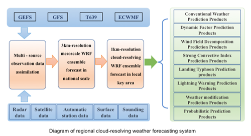
In recent years, high-performance computing has been greatly improved. At the same time, understanding of atmospheric physical processes has also been elevated to a new height. On these bases, our research group developed the Regional Cloud-Distinguished Weather Forecast System. The main purpose of this system is to provide accurate and precise forecasting products and improve the forecasting accuracy of heavy rainfall, strong convection, typhoons and other high-impact weather. The system runs twice a day, at 0000 UTC and 1200 UTC, predicting the weather condition 72 hours in advance over China at a horizontal grid spacing of 3 km, and some key areas with a horizontal grid spacing of 1 km. In terms of structure, the system can be divided into four general parts. The first part is the Multi-source Observation Data Assimilation Module, which integrates the prediction fields of several numerical prediction centers and various conventional or irregular meteorological observations to establish the assimilation analysis field. The second part is the Regional Cloud-distinguished Weather Module, which takes the WRF mesoscale model as its core, carrying out mesoscale ensemble forecasts with multiple initial values and multiple physical schemes. The third part is the Post-processing Module, which can provide the analysis field product and the assembly forecast product. The fourth part is the System Management Plan, which is designed to control the overall operation of the system and monitor the running state. Compared with the GRAPES mesoscale ensemble forecasting system of the China Meteorological Administration and the CAPS-scale ensemble prediction system in the spring experiment of Oklahoma University, this system has obvious advantages in terms of the horizontal resolution and assimilation data source.
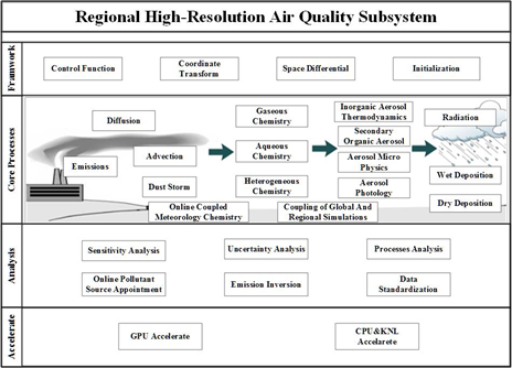
Regional High-Resolution Air Pollution Modeling
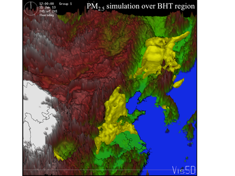
Atmospheric pollution management requires knowledge of the sources and evolution of atmospheric pollutants and their impacts on atmosphere visibility. The Regional High-Resolution Air Pollution Modeling Subsystem aims to develop a new-generation air environment modeling system. It includes an aerosol microdynamic module, secondary organic aerosol module, a combined moisture absorption and growth of aerosol components module, visibility module, and toxicity module. It will involve advanced modeling techniques, such as emissions inversion, data assimilation, ensemble forecasting, and source apportionment. The system consists of 28 core modules and will enable high-resolution modeling of air pollutants at 3-km resolution over the whole of China, and at 1-km resolution at the city scale. The system can investigate the evolution and interaction mechanism of atmospheric pollutants in the atmospheric boundary layer, the nonlinear response relationship between atmospheric pollutant emissions and haze, and the key factors involved in regional haze. It can evaluate the contributions of different sources to the concentrations of air pollutants. It can improve the accuracy of air quality forecasting and severe haze warning at both city and regional scales in China.
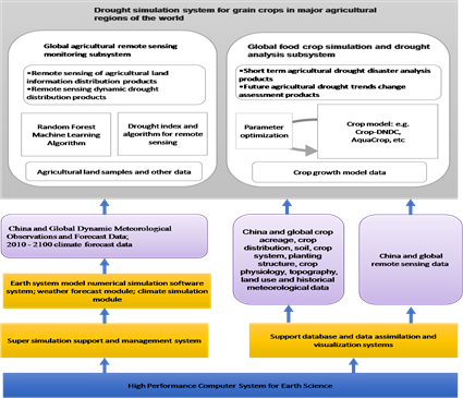
Drought Modeling Subsystem for Grain Crops in Major Agricultural Regions
The Drought Modeling Subsystem for Grain Crops in Major Agricultural Regions will enable simulations of the global agricultural remote sensing drought index and the formation of agricultural drought. It can automatically extract the global farmland distribution, including paddies, drylands, and irrigated water areas. It will include a global database of six major cereal crops (rice, maize, wheat, sorghum, rice and barley) and a growth modeling module. It will enable the simulation of food-crop growth in China and in major agricultural areas worldwide under conditions of real-time meteorological observations and dynamic analysis data.
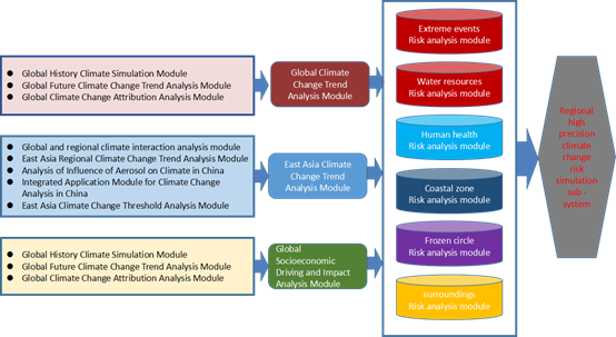
Regional High-Precision Long-term Climate Change Risk Modeling
The Regional High-Precision Long-term Climate Change Risk Modeling Subsystem is designed to analyze the trends of global climate change, the trends and thresholds of East Asian climate, the impacts of East Asian climate change on China's living environment, and the impacts of global climate change on global and domestic socioeconomics.